In short
A cadastral map is the drawing of the boundaries of every property, municipality by municipality. The territory is divided into sheets (fogli); inside each sheet, the large numbers are the parcels (particelle), that is the individual pieces of land or the buildings. To identify a property you need three things: the municipality, the sheet number and the parcel number.
What to look at, in order
The numbers on the figure refer to the list below.
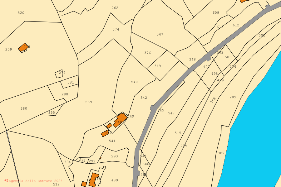
Scroll the figure to read the details →
- 1The parcel number. It is its name inside the sheet, and without municipality and sheet it identifies nothing.
- 2The boundary between two parcels. A solid line: it is a map boundary, with its drawing tolerance.
- 3Buildings, filled in solid. They too sit inside a parcel and carry its number.
- 4Roads, in grey. They are not parcels: they are areas for traffic.
- 5Water, in light blue: rivers, ditches and bodies of water.
- 6An isolated building in the middle of a field: a barn, an outbuilding, a ruin.
The territory is divided into sheets
Every municipality is divided into cadastral sheets (fogli), numbered from 1 upwards. A sheet is a portion of territory small enough to fit on a readable drawing: a small municipality may have about ten, a city several hundred. The sheet number means nothing on its own: it only ever applies inside one specific municipality.
Inside the sheet are the parcels
The parcel (particella, in many areas called mappale) is the unit of the map: a piece of land with a single owner and a single crop type, or the area occupied by a building. It is the large number you see inside the boundary. Two neighbouring parcels can belong to the same owner and stay separate, for example because one is vineyard and the other woodland.
And the sub-unit?
The sub-unit (subalterno) does not appear on the land map: it identifies the single units inside a building, that is the individual flat, the cellar, the garage. On the map you see the outline of the building with its parcel number; what is inside is in the cadastral floor plans (planimetrie), which are a different document.
| What it identifies | Example | Where you read it | |
|---|---|---|---|
| Sheet (foglio) | a portion of the municipal territory | Foglio 12 | in the frame of the map, at the top of the cadastral record |
| Parcel (particella) | the single piece of land, or the plot a building stands on | Particella 348 | the large number inside the boundary |
| Sub-unit (subalterno) | the unit inside the building: flat, cellar, garage | Sub 5 | in the cadastral record and the floor plan, not on the map |
Lines, dashes and symbols
A parcel boundary is a solid line. Roads and water have no parcel number: the name is written along the route. Buildings are filled in. Dashed lines mark buildings under construction or accessory parts. Older maps still carry hand-drawn marks, because in many municipalities the original map is a hundred years old and every subdivision has been drawn on top of it.
Why the map is not enough to settle a boundary
How to look at it for free
Cadastral cartography is public and can also be consulted on the portal of the Agenzia delle Entrate (Italian Revenue Agency). Here the same cartography is on a single map of Italy: zoom, search by address or by municipality, boundaries that open on click, without SPID (the Italian digital identity) and without signing up.
All of Italy, no sign-up.
Continue from here
Find your municipality
Source: cadastral cartography of the Agenzia delle Entrate (WMS service), CC BY 4.0 licence · Content checked on 8 October 2026