In short
The cadastral parcel (particella catastale) is the smallest portion of territory recorded by the Italian cadastre: a piece of land with a single holder and a single crop type, or the area a building stands on. It is always identified by three things together: municipality, sheet, parcel number. The number alone identifies nothing.
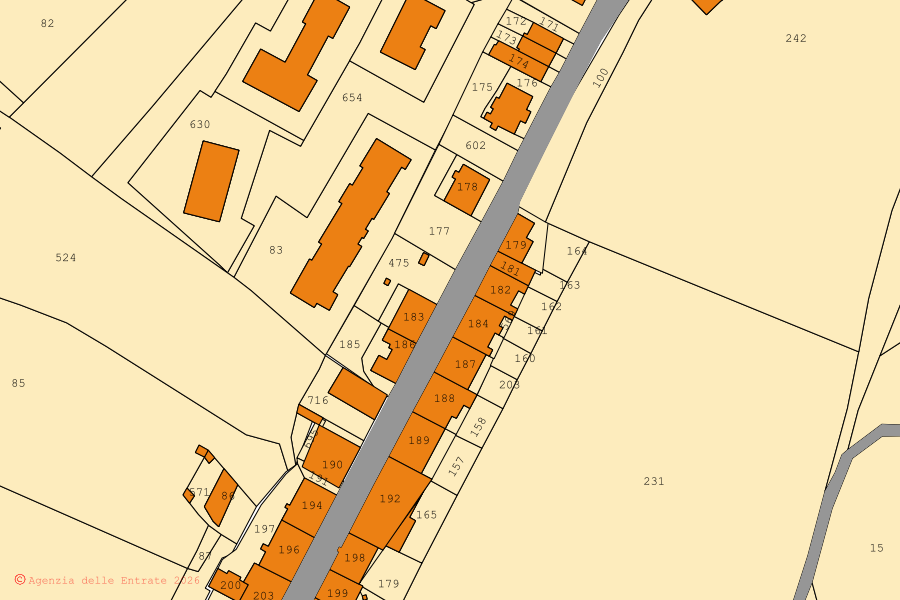
Scroll the figure to read the details →
- 1A parcel can be a building: the house with its number, as a whole.
- 2A parcel can be a piece of land: a single field, with a single crop type.
- 3The courtyard around the house is often a parcel of its own, with its own number.
The three coordinates
Municipality, sheet, parcel. The municipality is written with its cadastral code (four characters, for example H501 for Rome): it is the code you find at the top of cadastral records and in deeds. The sheet applies inside the municipality, the parcel inside the sheet. Change one of the three and you are somewhere else in Italy.
| municipality | with its cadastral code: H501 is Rome, H319 Riparbella |
| sheet (foglio) | applies inside that municipality, and means nothing on its own |
| parcel (particella) | applies inside that sheet |
Particella and mappale are the same thing
In everyday speech and in many deeds people say mappale. In the land cadastre the word is particella. They are the same thing: in the buildings cadastre the same numbering identifies the plot the building stands on.
What the cadastre says about your parcel
Besides the geometry, the cadastre keeps the record data for every parcel.
Land
- Cadastral area
- Crop type and class
- Reddito dominicale (income attributed to the owner)
- Reddito agrario (income attributed to farming)
Buildings
- Category (A/2, C/6…)
- Class
- Size (rooms, m²)
- Rendita catastale (cadastral income)
Reddito dominicale and reddito agrario are the two values on which taxes on land are calculated.
Why your parcel may have changed number
When a parcel is split (a subdivision, frazionamento) or two parcels are merged, the cadastre assigns new numbers and the old number is suppressed. This is why a deed from 1980 can carry numbers that no longer exist on today's map. The continuity is reconstructed from the deeds, not from the map.
How do I find mine
Three ways, in order of convenience: from the map, searching for the address and clicking the land; from the documents you already have (purchase deed, cadastral record, IMU property tax notice, floor plan); by entering municipality, sheet and parcel below. Searching from the address has its own guide: How to find sheet and parcel.
Continue from here
Find your municipality
Source: cadastral cartography of the Agenzia delle Entrate (WMS service), CC BY 4.0 licence · Content checked on 8 October 2026