In short
The visura catastale (cadastral record) is the snapshot of a property in the archives of the cadastre: identifiers, surface area, category, cadastral income and who is registered as owner. It is requested from the Agenzia delle Entrate (Italian Revenue Agency), on other people's property too.
How to get it · from us
Who is the registered owner, and how many square metres is it?
i
The official cadastral record (visura catastale), as a PDF. No SPID needed, pay by card from abroad too. Usually ready in under a minute, not instant · you pay at checkout, then we fetch it.Several documents on the same parcel, in a single payment. From the map →
Free, on the map
What you see here, without the record
The boundaries and area of the parcel are on the map. If you were looking for its shape or size, you do not need the cadastral record.
Open the map →The document at a glance
How to read a visura
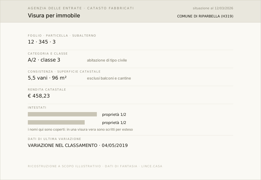
Six entries matter, and on the figure each one has its number.
Scroll the figure to read the details →
- 1Foglio, particella, subalterno (sheet, parcel, unit). The cadastral address of the property.
- 2Categoria e classe (category and class). A/2, C/6: the recorded use and the quality band.
- 3Consistenza e superficie (size and surface area). Rooms (vani) or square metres: not the same thing as the square metres in a listing.
- 4Rendita (cadastral income). The base on which taxes are calculated.
- 5Intestati (registered owners). Name, share and right: ownership, usufruct, bare ownership.
- 6Ultima variazione (latest change). Date and type of the latest update: it says how old the data is.
The document after this one
Continue from here
Find your municipality
Costs, channels and access requirements are procedures of the body that issues the document, checked at source on 28 July 2026. Before you act, check on the body's website.