Em resumo
A planimetria catastale (planta cadastral) é o desenho interno de uma unidade imobiliária: cômodos, medidas, alturas, uso de cada cômodo. Diferente da visura, nem todos podem pedir: só quem tem um direito sobre o imóvel ou alguém com delegação dele.
O documento em resumo
How to read a planimetria
It is not the estate agent's sketch: it is a filed technical drawing, to scale, with a title block carrying the cadastral data. And the measurements it gives are not the square metres you read in listings.
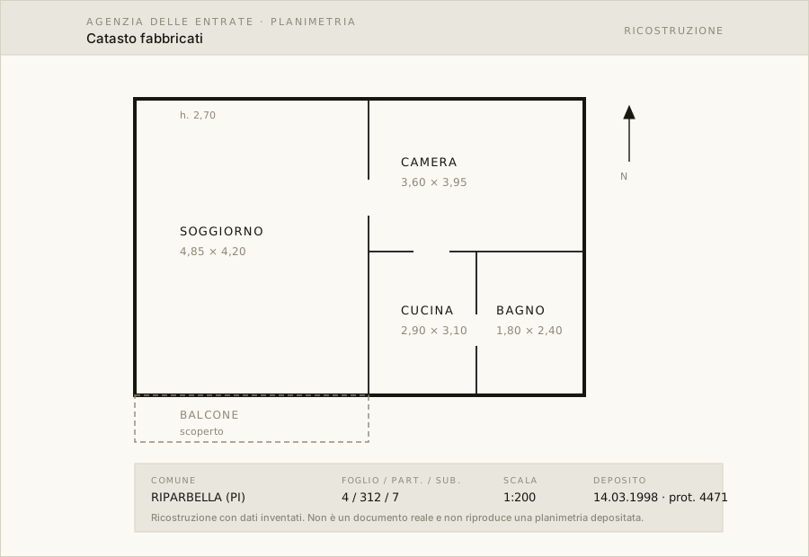
Role a figura para ler os detalhes →
- 1The title block. Municipality, sheet, parcel and unit (subalterno): they say which property the drawing belongs to. If they do not match the visura, the problem is there.
- 2The walls. A thick line is a load-bearing or perimeter wall, a thin one a partition. They are the filed state, not necessarily today's.
- 3The room measurements. In metres, taken on the inside face. Adding them up does not give the floor area in the listing: that is measured another way.
- 4The scale. Normally 1:200, 1:100 for small units. It lets you measure on the drawing what has no dimension written on it.
- 5Balconies and appurtenances. Drawn but counted separately: an open balcony is not living area.
- 6North. It says how the house is oriented: which room gets the sun and which does not.
- 7Date and reference number of the filing. It is the date of the snapshot. If the works date from 2015 and this says 1998, the drawing is two renovations old.
Cadastral conformity and planning conformity
Cadastral conformity means that the filed floor plan matches how the property is built today: the notary checks it at the deed. Planning conformity means that this state was authorised: it is in the building permits held by the municipality. A house can be perfectly in line with the cadastre and still have a building irregularity.
Como obter · não conosco
We cannot get this one for you
The Agenzia issues it only to the registered owner or their delegate, and the channel we use does not offer it. We would rather say so here than have you find out after paying.
Onde obter, então
The reserved area of the Agenzia delle Entrate with SPID or CIE, if you are the registered owner. Otherwise a written delegation is needed, and a surveyor or a notary takes it to the counter.
custos e canais verificados em 28 July 2026
Grátis no mapa
You have the outline of the building here
The floor plan is the inside. The perimeter, the number of registered floors and the area are already on the map, for free.
Open the map →O documento seguinte
Continue daqui
Encontre o seu município
Custos, canais e requisitos de acesso são procedimentos do órgão que emite o documento, verificados na fonte em 28 de julho de 2026. Antes de agir, confira no site do órgão.