Kurz gesagt
Die planimetria catastale (Katastergrundriss) ist die Innenzeichnung einer Immobilieneinheit: Räume, Maße, Höhen, Nutzung jedes Raums. Anders als die visura kann sie nicht jeder beantragen: nur wer ein Recht an der Immobilie hat, oder ein Bevollmächtigter.
Das Dokument auf einen Blick
How to read a planimetria
It is not the estate agent's sketch: it is a filed technical drawing, to scale, with a title block carrying the cadastral data. And the measurements it gives are not the square metres you read in listings.
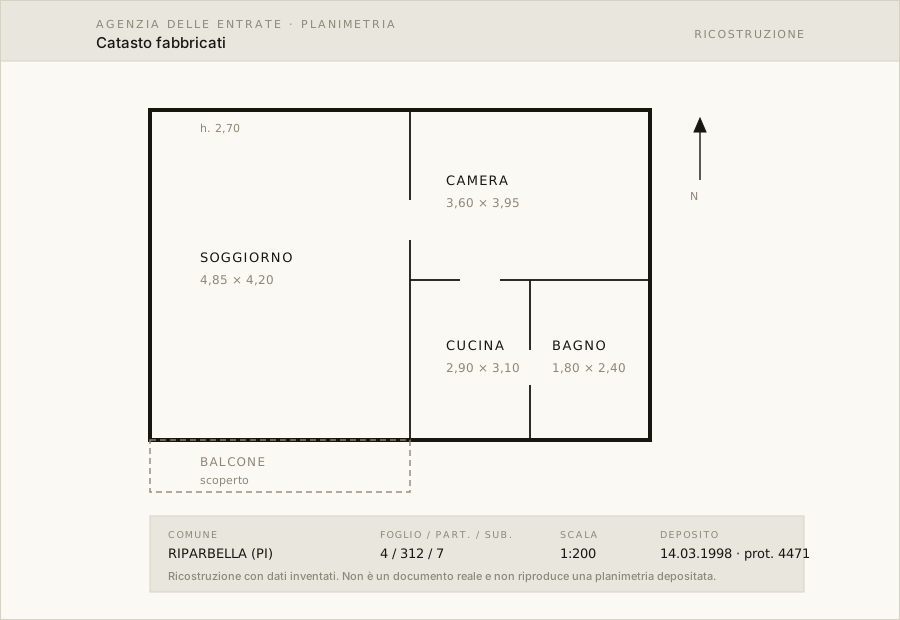
Wischen Sie über die Abbildung, um die Details zu lesen →
- 1The title block. Municipality, sheet, parcel and unit (subalterno): they say which property the drawing belongs to. If they do not match the visura, the problem is there.
- 2The walls. A thick line is a load-bearing or perimeter wall, a thin one a partition. They are the filed state, not necessarily today's.
- 3The room measurements. In metres, taken on the inside face. Adding them up does not give the floor area in the listing: that is measured another way.
- 4The scale. Normally 1:200, 1:100 for small units. It lets you measure on the drawing what has no dimension written on it.
- 5Balconies and appurtenances. Drawn but counted separately: an open balcony is not living area.
- 6North. It says how the house is oriented: which room gets the sun and which does not.
- 7Date and reference number of the filing. It is the date of the snapshot. If the works date from 2015 and this says 1998, the drawing is two renovations old.
Cadastral conformity and planning conformity
Cadastral conformity means that the filed floor plan matches how the property is built today: the notary checks it at the deed. Planning conformity means that this state was authorised: it is in the building permits held by the municipality. A house can be perfectly in line with the cadastre and still have a building irregularity.
So bekommen Sie es · nicht bei uns
We cannot get this one for you
The Agenzia issues it only to the registered owner or their delegate, and the channel we use does not offer it. We would rather say so here than have you find out after paying.
Wo Sie es dann bekommen
The reserved area of the Agenzia delle Entrate with SPID or CIE, if you are the registered owner. Otherwise a written delegation is needed, and a surveyor or a notary takes it to the counter.
Kosten und Wege geprüft am 28 July 2026
Kostenlos, auf der Karte
You have the outline of the building here
The floor plan is the inside. The perimeter, the number of registered floors and the area are already on the map, for free.
Open the map →Das Dokument danach
Von hier aus weiter
Ihre Gemeinde finden
Kosten, Wege und Zugangsvoraussetzungen sind Verfahren der Stelle, die das Dokument ausstellt. Wir haben sie am 28. Juli 2026 an der Quelle geprüft. Prüfen Sie vor jedem Schritt die Website der Stelle.